processed
PDF files1
Pages3
Objects18
Processing100%
main viewer
Selected page objects
 Bridge General Arrangement Drawing
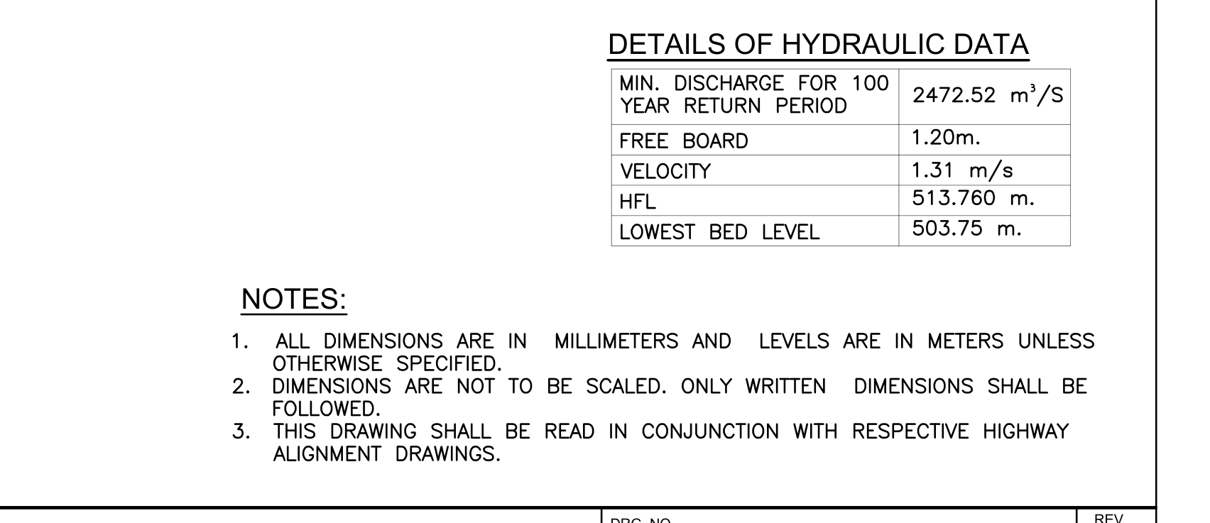 Hydraulic Data And General Notes
 Legend Of Abbreviations And Symbols Used In Bridge Ga Drawing
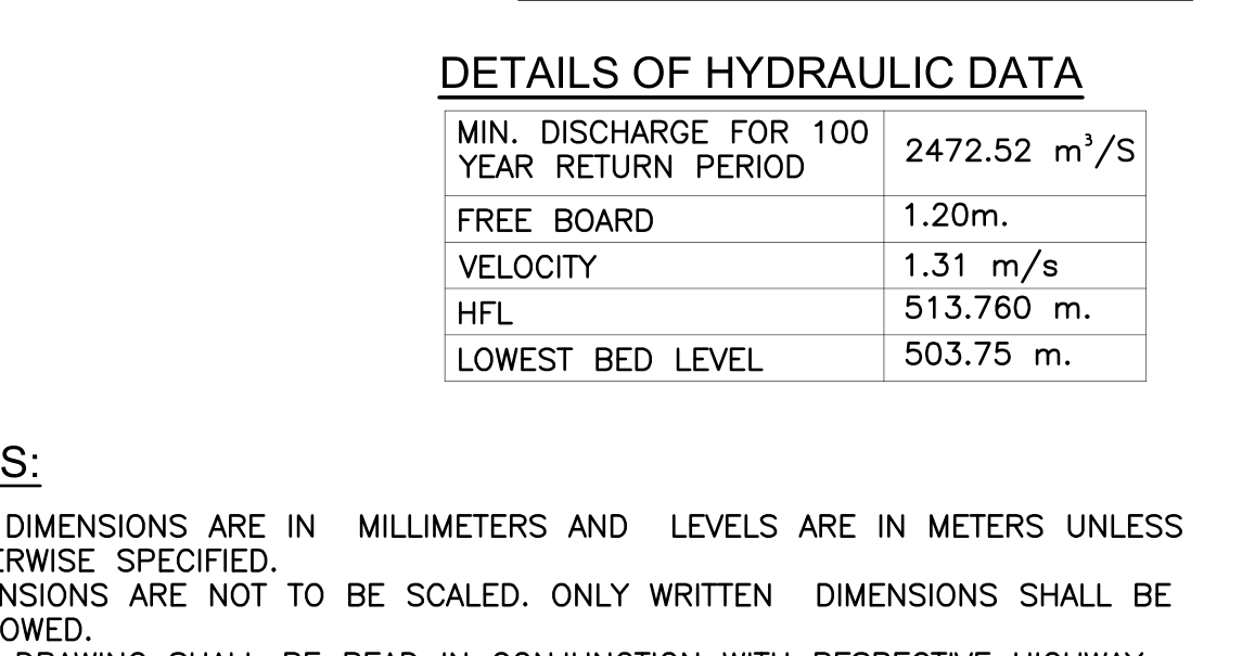 Hydraulic Data
 Bridge Approach And Deck Plan
 Bridge Deck And Foundation Plan With Key Plan
 Bridge Site Layout And Approach Roads
cropped image preview
CloseBridge Approach And Deck Plan
- Object
- Bridge Approach And Deck Plan
- Explanation
- half plan of bridge deck and approach slabs
- View
- plan
- Structure
- proposed bridge at CH 64+412
- Part of structure
- superstructure - deck
- Shows
- approach slab, carriageway, footpath, median, rcc crash barrier, expansion joint, trees/landscaping
- Component
- bridge_approach_and_deck_plan
- Identifier
- n/a
- Section
- n/a
- Drawing no.
- n/a
- Scale
- 1:300
- Discipline
- bridge_structural
- Accuracy
- 90%+
- Tier
- max
- Page
- 371
- Bounding box
- 0.000, 0.004, 0.467, 0.604
- Remarks
- No validated same-instance relation.
- QA comments
- review_required=True; mapping_relation=unresolved_singleton
- Linked tables
- DETAILS OF HYDRAULIC DATA (same page)
- Cloudinary URL
- Open image
Raw extracted data
{
  "id": 4939,
  "type": "Substructure",
  "view-angle": "none",
  "bbox": [
    0,
    0.00448225737494656,
    0.46697975219099425,
    0.6043249251817017
  ],
  "confidence_score": 0.72,
  "remarks": "No validated same-instance relation.",
  "qa-comments": "review_required=True; mapping_relation=unresolved_singleton",
  "column": "bridge_approach_and_deck_plan",
  "url": "https://res.cloudinary.com/laiuauox/image/upload/v1785779791/edapro/structural_drawings_pkg_1-ddb226084eea471bb5ba3adf2eb67975/items/bridge_approach_and_deck_plan_p01_r03.png",
  "item_key": "bridge_approach_and_deck_plan_p01_r03",
  "label": "Bridge Approach And Deck Plan",
  "caption": "half plan of bridge deck and approach slabs",
  "view_type": "plan",
  "section_label": null,
  "region_kind": "drawing",
  "drawing_number": null,
  "scale": "1:300",
  "area": "deck",
  "structure": "proposed bridge at CH 64+412",
  "structure_part": "superstructure - deck",
  "elements": [
    "approach slab",
    "carriageway",
    "footpath",
    "median",
    "rcc crash barrier",
    "expansion joint",
    "trees/landscaping"
  ],
  "identifiers": [
    "A1",
    "P1",
    "40000(SQ) 46189(SK)",
    "37761(SQ) 43603(SK)",
    "1070(SQ) 1236(SK)",
    "1170(SQ) 1350(SK)",
    "30° SKEW"
  ],
  "referenced_sheets": [],
  "uncertainty_codes": [
    "composite_scope",
    "ambiguous_boundary"
  ],
  "tier": "max",
  "identifier": null,
  "discipline": "bridge_structural",
  "view_types": [
    "plan"
  ],
  "linked_notes": "LEGEND (same page); DETAILS OF HYDRAULIC DATA / NOTES (same page)",
  "linked_tables": "DETAILS OF HYDRAULIC DATA (same page)",
  "shape_summary": {
    "circle": 2,
    "rectangle": 7,
    "line_run": 14,
    "hatch": 5,
    "polygon": 51,
    "total": 79
  },
  "merged_from": null,
  "page_id": 371,
  "file_id": 71,
  "project_id": "6a70d38ab3c2d3afd675b2b4",
  "token_count": 428969
}