processed
PDF files1
Pages3
Objects22
Processing100%
main viewer
Selected page objects
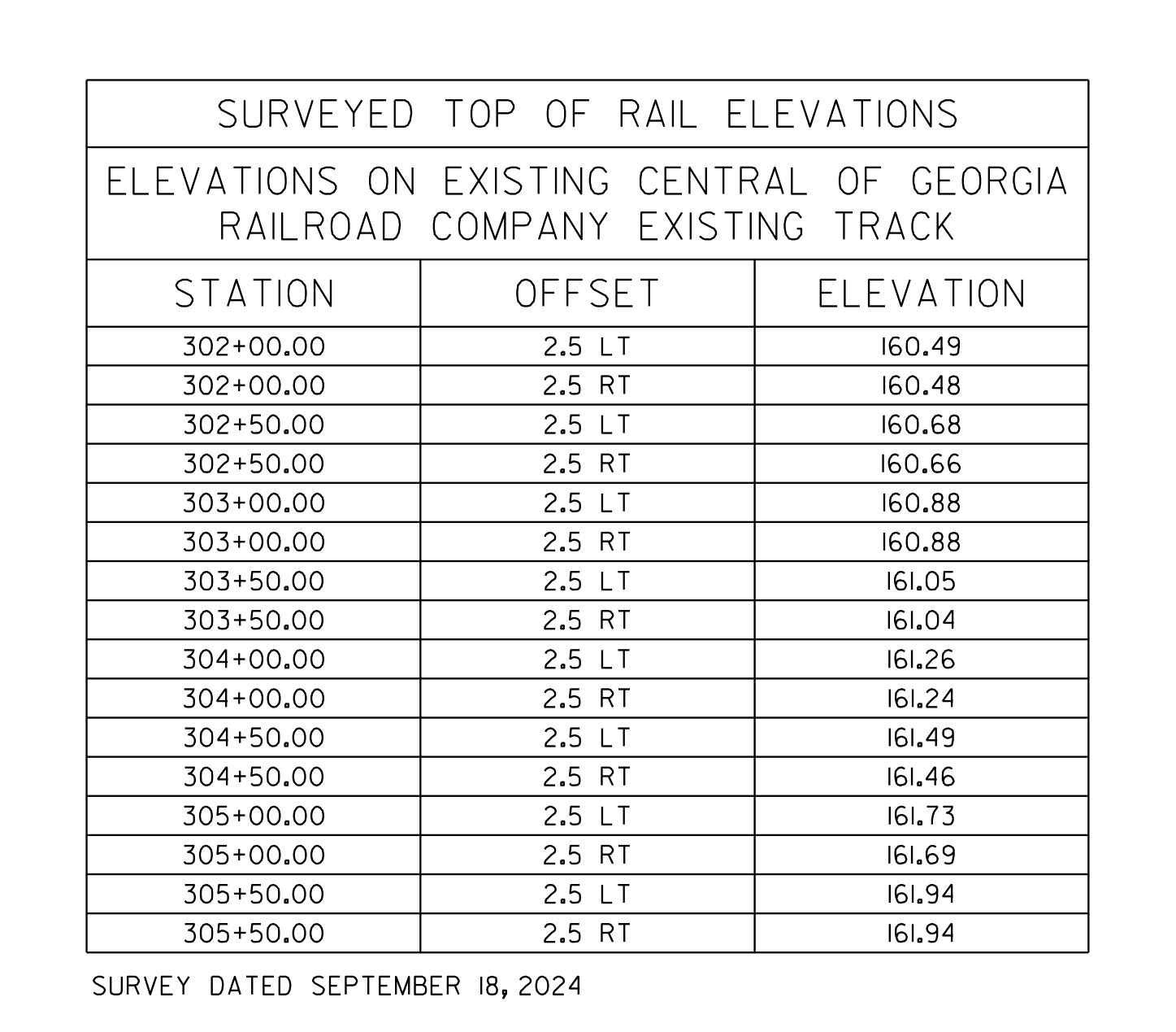 Surveyed Top Of Rail Elevations
 Title Block And Revision Cartouche
 Existing Track Alignment And Rail Elevations
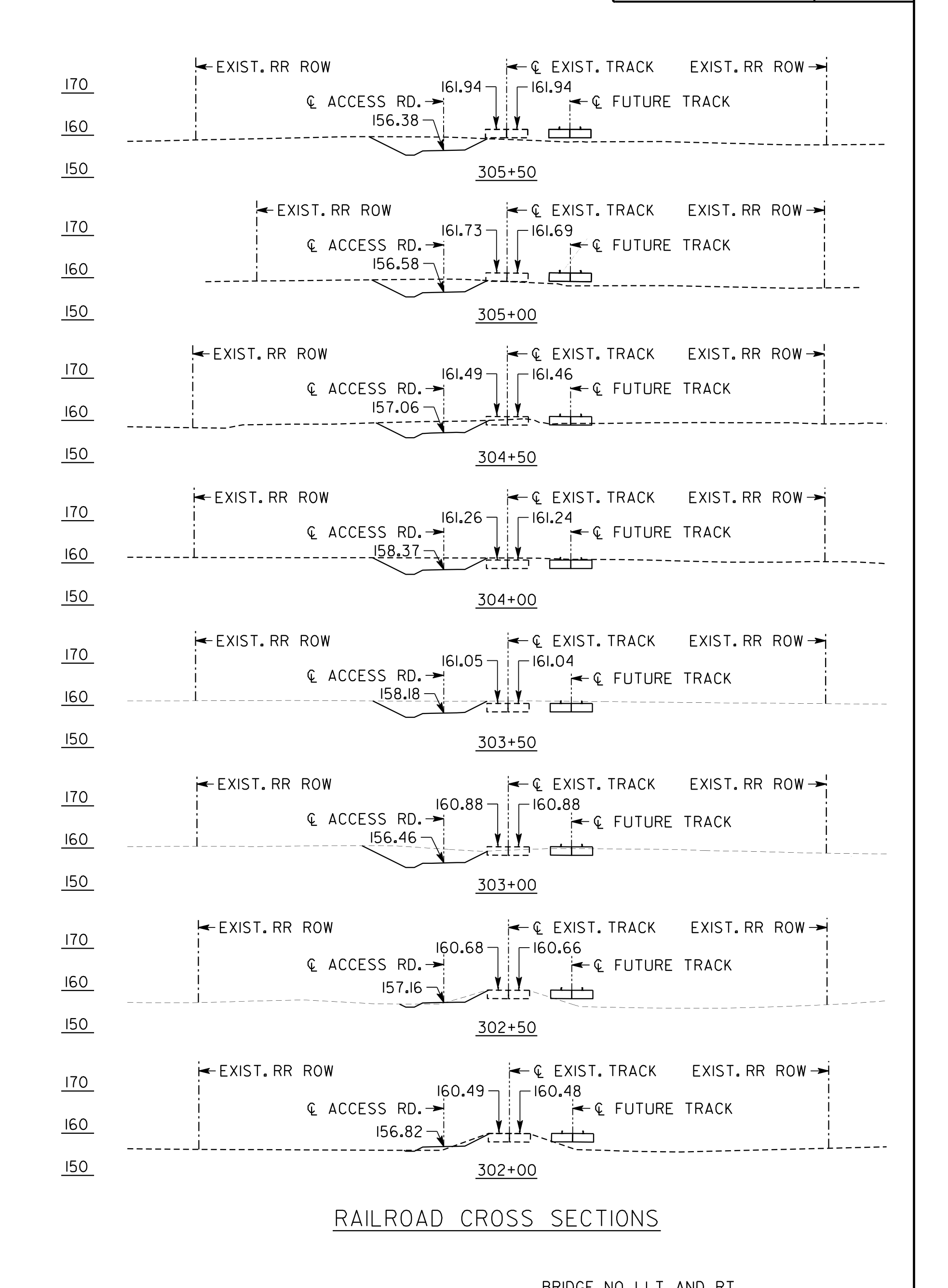 Railroad Existing Track Geometry
cropped image preview
CloseRailroad Existing Track Geometry
- Object
- Railroad Existing Track Geometry
- Explanation
- multiple cross sections showing existing track, access road, and future track elevations
- View
- cross_section
- Structure
- existing central of Georgia railroad company track
- Part of structure
- track - existing alignment
- Shows
- existing rr row, existing track, access road, future track, elevation markings, centerline references, station markers
- Component
- railroad_existing_track_geometry
- Identifier
- n/a
- Section
- n/a
- Drawing no.
- n/a
- Scale
- n/a
- Discipline
- rail
- Accuracy
- 90%+
- Tier
- max
- Page
- 364
- Bounding box
- 0.667, 0.045, 0.997, 0.739
- Remarks
- No validated same-instance relation.
- QA comments
- review_required=True; mapping_relation=unresolved_singleton
- Linked tables
- SURVEYED TOP OF RAIL ELEVATIONS (same page)
- Cloudinary URL
- Open image
Raw extracted data
{
  "id": 4713,
  "type": "Substructure",
  "view-angle": "cross section",
  "bbox": [
    0.6666823529411765,
    0.04478181818181817,
    0.9968470588235294,
    0.7385454545454545
  ],
  "confidence_score": 0.82,
  "remarks": "No validated same-instance relation.",
  "qa-comments": "review_required=True; mapping_relation=unresolved_singleton",
  "column": "railroad_existing_track_geometry",
  "url": "https://res.cloudinary.com/laiuauox/image/upload/v1785753976/edapro/gdot_plan-d4fa640ccb0c4bbeaad5c0ecd7506e87/items/railroad_existing_track_geometry_p03_r02.png",
  "item_key": "railroad_existing_track_geometry_p03_r02",
  "label": "Railroad Existing Track Geometry",
  "caption": "multiple cross sections showing existing track, access road, and future track elevations",
  "view_type": "cross_section",
  "section_label": null,
  "region_kind": "drawing",
  "drawing_number": null,
  "scale": null,
  "area": "track alignment",
  "structure": "existing central of Georgia railroad company track",
  "structure_part": "track - existing alignment",
  "elements": [
    "existing rr row",
    "existing track",
    "access road",
    "future track",
    "elevation markings",
    "centerline references",
    "station markers"
  ],
  "identifiers": [
    "305+50",
    "305+00",
    "304+50",
    "304+00",
    "303+50",
    "303+00",
    "302+50",
    "302+00"
  ],
  "referenced_sheets": [],
  "uncertainty_codes": [
    "unreadable_text",
    "composite_scope"
  ],
  "tier": "max",
  "identifier": null,
  "discipline": "rail",
  "view_types": [
    "cross_section"
  ],
  "linked_notes": null,
  "linked_tables": "SURVEYED TOP OF RAIL ELEVATIONS (same page)",
  "shape_summary": {
    "line_run": 2,
    "polygon": 112,
    "total": 114
  },
  "merged_from": null,
  "page_id": 364,
  "file_id": 68,
  "project_id": "6a706fee4418133786fb61e9",
  "token_count": 253867
}